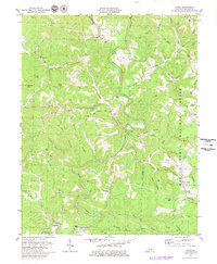
1979 Map of Dykes
USGS Topo · Published 1980About this map
Buck Creek carves a winding path through this corner of Pulaski County, defining a landscape where small settlements and rural homesteads follow the high ridges. The eastern portion of the sheet is dominated by the Daniel Boone National Forest, a territory marked by deep drainages like Whetstone Creek and the unusual geological feature known as The Sinks. Smaller communities such as Poplarville and Dykes serve as focal points for local life, while Mount Victory sits on the southern high ground near the forest boundary.
Find a feature on this map
97 named features on this map. Tap any name to fly to it.
Don’t see what you’re looking for? This feature index may not catch every label — zoom into the map to look around manually.
Map Details
Editions of this 1979 Dykes Map
This is the sole edition of this map. No revisions or reprints were ever made.
Other maps of this area

1890 · Williamsburg
USGS Topo · 1:125,000

1893 · London
USGS Topo · 1:125,000

1894 · Williamsburg
USGS Topo · 1:125,000

1897 · London
USGS Topo · 1:125,000

1932 · Burnside
USGS Topo · 1:62,500

1935 · Somerset
USGS Topo · 1:62,500

1952 · Hail
USGS Topo · 1:24,000

1952 · Billows
USGS Topo · 1:24,000

1952 · Ano
USGS Topo · 1:24,000

1952 · Dykes
USGS Topo · 1:24,000