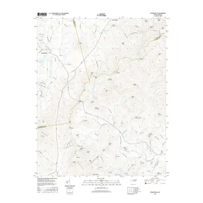
2016 Map of Dysartsville
USGS Topo · Published 2016About this map
Dysartsville and Brindletown anchor this rural landscape where three North Carolina counties — McDowell, Burke, and Rutherford — meet. The terrain is defined by the South Mountains range, featuring prominent landmarks like Pilot Mtn and Devils Fork Mtn. Waterways dictate the valley routes, notably the headwaters of the First Broad River and its various forks, including Molly Fork and Little First Broad River. For those researching local lineages, the map identifies several rural burial grounds such as Fairview Cem, Golden Valley Cem, and Fortune Cem, alongside the First Broad Church. The presence of the Muddy Cr B S A Lake and names like Gold Mine Rd reflect the area's long-standing intersection of natural resources and outdoor activity. The network of winding mountain roads like Vein Mountain Rd and Cane Creek Mountain Rd illustrates the historical pathways through these gaps and ridges.
Find a feature on this map
153 named features on this map. Tap any name to fly to it.
Don’t see what you’re looking for? This feature index may not catch every label — zoom into the map to look around manually.
Map Details
Editions of this 2016 Dysartsville Map
This is the sole edition of this map. No revisions or reprints were ever made.
Other maps of this area

1905 · Morganton
USGS Topo · 1:125,000

1950 · Shelby
USGS Topo · 1:62,500

1953 · Charlotte
USGS Topo · 1:250,000

1954 · Charlotte
USGS Topo · 1:250,000

1956 · Benn Knob
USGS Topo · 1:24,000

1956 · Morganton South
USGS Topo · 1:24,000

1960 · Charlotte
USGS Topo · 1:250,000

1962 · Charlotte
USGS Topo · 1:250,000
1962 · Glen Alpine
USGS Topo · 1:24,000
1962 · Glenwood
USGS Topo · 1:24,000