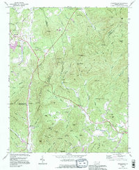
1993 Map of Dysartsville
USGS Topo · Published 1996About this map
The First Broad River meanders through this landscape, which straddles the borders of Burke, McDowell, and Rutherford Counties. Dysartsville serves as a primary settlement node in the northwest, while the hamlet of Brindletown is situated near the northern edge. The area is defined by a dense network of knobs and gaps, including Pilot Mtn and Wolf Pen Mountain, which overlook the complex drainage systems of Muddy Creek and Silver Creek.
Find a feature on this map
86 named features on this map. Tap any name to fly to it.
Don’t see what you’re looking for? This feature index may not catch every label — zoom into the map to look around manually.
Map Details
Editions of this 1993 Dysartsville Map
This is the sole edition of this map. No revisions or reprints were ever made.
Other maps of this area

1905 · Morganton
USGS Topo · 1:125,000

1950 · Shelby
USGS Topo · 1:62,500

1953 · Charlotte
USGS Topo · 1:250,000

1954 · Charlotte
USGS Topo · 1:250,000

1956 · Benn Knob
USGS Topo · 1:24,000

1956 · Morganton South
USGS Topo · 1:24,000

1960 · Charlotte
USGS Topo · 1:250,000

1962 · Charlotte
USGS Topo · 1:250,000
1962 · Glen Alpine
USGS Topo · 1:24,000
1962 · Glenwood
USGS Topo · 1:24,000