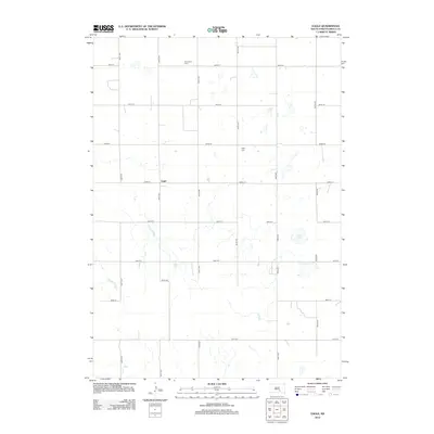
2012 Map of Eagle
USGS Topo · Published 2012About this map
Eagle and its surrounding prairie landscape are documented here in Brule County, revealing a sparse agricultural network defined by a rigid grid of section-line roads. The small settlement is situated near the intersection of 263rd St and 355th Ave, serving as a central point in this rural township. Local history is anchored by two distinct burial sites: Bohemian Cem to the north and Eagle Cem further east, reflecting the heritage of the families who settled this part of South Dakota. The terrain is dotted with small wetlands and seasonal depressions typical of the region, with Smith Lake and the winding course of Nelson Cr providing the primary hydrological features in an otherwise dry upland environment.
Find a feature on this map
19 named features on this map. Tap any name to fly to it.
Don’t see what you’re looking for? This feature index may not catch every label — zoom into the map to look around manually.
Map Details
Editions of this 2012 Eagle Map
This is the sole edition of this map. No revisions or reprints were ever made.
Other maps of this area

1955 · Mitchell
USGS Topo · 1:250,000

1959 · Mitchell
USGS Topo · 1:250,000

1971 · Lucas NW
USGS Topo · 1:24,000

1971 · Academy
USGS Topo · 1:24,000

1979 · Bijou Hills NE
USGS Topo · 1:24,000

1979 · Eagle
USGS Topo · 1:24,000
1979 · Red Lake East
USGS Topo · 1:24,000
1979 · Bijou Hills
USGS Topo · 1:24,000

1979 · Lake George
USGS Topo · 1:24,000

1979 · Kimball South
USGS Topo · 1:24,000