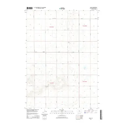
2015 Map of Eagle
USGS Topo · Published 2015About this map
Bijou Hills rises as a prominent landmark in this southern South Dakota landscape, anchoring a region defined by its wide section-line grid and scattered water features. The map details the small settlement of Eagle and the surrounding township, where the rural character is preserved through a network of gravel roads such as 354th Ave and 263rd St. Local heritage is marked by the Bohemian Cem and Eagle Cem, providing specific points of interest for genealogists tracing family histories in Brule County. The terrain transitions from the higher elevations of the hills down toward drainages like Nelson Cr and smaller basins such as Smith Lake. This 2015 survey reflects the enduring agricultural layout established during the original land office surveys, showing how the Public Land Survey System continues to dictate the local geography.
Find a feature on this map
25 named features on this map. Tap any name to fly to it.
Don’t see what you’re looking for? This feature index may not catch every label — zoom into the map to look around manually.
Map Details
Editions of this 2015 Eagle Map
This is the sole edition of this map. No revisions or reprints were ever made.
Other maps of this area

1955 · Mitchell
USGS Topo · 1:250,000

1959 · Mitchell
USGS Topo · 1:250,000

1971 · Lucas NW
USGS Topo · 1:24,000

1971 · Academy
USGS Topo · 1:24,000

1979 · Bijou Hills NE
USGS Topo · 1:24,000

1979 · Eagle
USGS Topo · 1:24,000
1979 · Red Lake East
USGS Topo · 1:24,000
1979 · Bijou Hills
USGS Topo · 1:24,000

1979 · Lake George
USGS Topo · 1:24,000

1979 · Kimball South
USGS Topo · 1:24,000