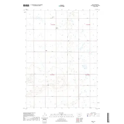
2017 Map of Eagle
USGS Topo · Published 2017About this map
Bijou Hills rise above the surrounding Brule County landscape, providing a distinct topographic profile in this section of South Dakota. The area is characterized by a sparse, rural settlement pattern centered near the small community of Eagle, where local history is anchored by several long-standing burial grounds. Genealogists and researchers will find the Bohemian Cem in the northern reaches, while the Holy Trinity Bendon Catholic Cem and Eagle Cem further south serve as markers of the families who settled this prairie. Drainage is defined by the winding path of Nelson Cr and the waters of Smith Lake, with the land organized by the section lines of the Public Land Survey System, including t102n r69w and t101n r68w.
Find a feature on this map
23 named features on this map. Tap any name to fly to it.
Don’t see what you’re looking for? This feature index may not catch every label — zoom into the map to look around manually.
Map Details
Editions of this 2017 Eagle Map
This is the sole edition of this map. No revisions or reprints were ever made.
Other maps of this area

1955 · Mitchell
USGS Topo · 1:250,000

1959 · Mitchell
USGS Topo · 1:250,000

1971 · Lucas NW
USGS Topo · 1:24,000

1971 · Academy
USGS Topo · 1:24,000

1979 · Bijou Hills NE
USGS Topo · 1:24,000

1979 · Eagle
USGS Topo · 1:24,000
1979 · Red Lake East
USGS Topo · 1:24,000
1979 · Bijou Hills
USGS Topo · 1:24,000

1979 · Lake George
USGS Topo · 1:24,000

1979 · Kimball South
USGS Topo · 1:24,000