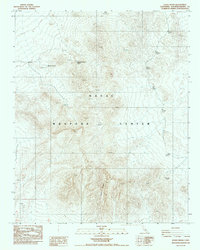
1987 Map of Eagle Crags
USGS Topo · Published 1987About this map
Eagle Crags dominates this high-elevation desert landscape in San Bernardino County, which by the late 1980s was largely encompassed by the Naval Weapons Center. The map provides a detailed look at the scattered water sources and traces of human activity in this arid environment, including Blue Chalcedony Spring and the Moonshine Spring (Dry). Evidence of early twentieth-century activity persists through labels for a Prospect and clusters of Ruins located near the northern springs. The terrain is marked by significant elevation changes, with several peaks noted by survey markers, reflecting the complex topography utilized by the military for testing and training. Remote outposts like Mesquite Spring sit along unimproved roads, illustrating the limited infrastructure of this protected desert range during the late Cold War era.
Find a feature on this map
10 named features on this map. Tap any name to fly to it.
Don’t see what you’re looking for? This feature index may not catch every label — zoom into the map to look around manually.
Map Details
Editions of this 1987 Eagle Crags Map
This is the sole edition of this map. No revisions or reprints were ever made.
Other maps of this area

1915 · Searles Lake
USGS Topo · 1:250,000

1933 · Avawatz Mountains
USGS Topo · 1:250,000

1947 · Trona
USGS Topo · 1:250,000

1948 · Trona
USGS Topo · 1:250,000

1948 · Quail Mountains
USGS Topo · 1:62,500

1948 · Goldstone Lake
USGS Topo · 1:62,500

1950 · Wingate Pass
USGS Topo · 1:62,500

1951 · Goldstone Lake
USGS Topo · 1:62,500

1951 · Wingate Pass
USGS Topo · 1:62,500

1951 · Quail Mountains
USGS Topo · 1:62,500