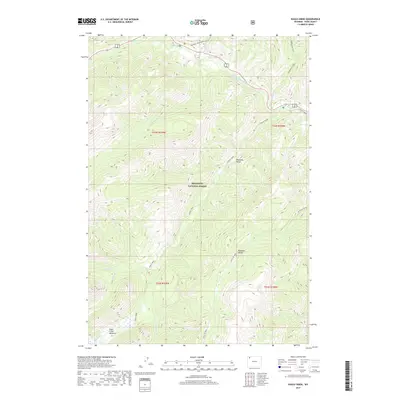
2017 Map of Eagle Creek
USGS Topo · Published 2017About this map
Shoshone National Forest contains the high-elevation drainage of Eagle Creek and its many tributaries, including Cloudburst Cr and Crouch Cr. This terrain within the Absaroka Range is defined by steep elevation changes, rising from the North Fork Shoshone River in the north toward protected backcountry meadows. The presence of Eagle Creek Meadows and Paradise Valley suggests traditional grazing areas or significant landmarks for mountain travelers. Historically used trails provide the primary access to these summits and basins, with the Kitty Cr Trail and Grinnell Trailhead Trail tracing the natural corridors between the peaks. The map highlights a landscape preserved from intensive development, focused instead on the hydrological network of Middle Cr, Grinnell Cr, and Mormon Cr.
Find a feature on this map
22 named features on this map. Tap any name to fly to it.
Don’t see what you’re looking for? This feature index may not catch every label — zoom into the map to look around manually.
Map Details
Editions of this 2017 Eagle Creek Map
This is the sole edition of this map. No revisions or reprints were ever made.
Other maps of this area

1885 · Lake
USGS Topo · 1:125,000

1886 · Canyon
USGS Topo · 1:125,000

1893 · Ishawooa
USGS Topo · 1:125,000

1895 · Ishawooa
USGS Topo · 1:125,000

1895 · Canyon
USGS Topo · 1:125,000

1895 · Lake
USGS Topo · 1:125,000

1896 · Lake
USGS Topo · 1:125,000

1896 · Canyon
USGS Topo · 1:125,000

1896 · Crandall Creek
USGS Topo · 1:125,000

1899 · Crandall
USGS Topo · 1:125,000