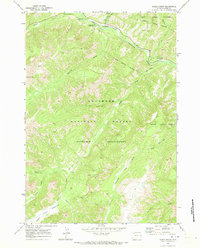
1970 Map of Eagle Creek
USGS Topo · Published 1973About this map
The North Fork Shoshone River carves through this high mountain corridor, where the 1970 landscape is defined by the recreation and wilderness management of the Shoshone National Forest. The map documents a cluster of campgrounds such as Pahaska Campground and Sleeping Giant Campground, alongside the Sleeping Giant Winter Sports Area. These features indicate the area's development as a gateway for travelers moving toward the western entrance of the nearby national park.
Find a feature on this map
29 named features on this map. Tap any name to fly to it.
Don’t see what you’re looking for? This feature index may not catch every label — zoom into the map to look around manually.
Map Details
Editions of this 1970 Eagle Creek Map
2 editions found
Other maps of this area

1885 · Lake
USGS Topo · 1:125,000

1886 · Canyon
USGS Topo · 1:125,000

1893 · Ishawooa
USGS Topo · 1:125,000

1895 · Ishawooa
USGS Topo · 1:125,000

1895 · Canyon
USGS Topo · 1:125,000

1895 · Lake
USGS Topo · 1:125,000

1896 · Lake
USGS Topo · 1:125,000

1896 · Canyon
USGS Topo · 1:125,000

1896 · Crandall Creek
USGS Topo · 1:125,000

1899 · Crandall
USGS Topo · 1:125,000