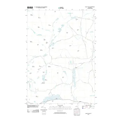
2010 Map of Eagle Lake
USGS Topo · Published 2010About this map
Ironville and Chilson serve as the primary anchors of this terrain in the eastern Adirondacks. The landscape is defined by its industrial and geologic heritage, evidenced by names like Furnace Mountain, Railroad Hill, and the historic transit route of Old Furnace Rd. Water bodies are a central theme of the topography, ranging from the large expanse of Eagle Lake at the southern edge, featuring Turtle Island and Eagle Cliff, to more secluded waters like Goosepuddle Pond and Snake Pond. Significant elevation changes are marked by numerous peaks such as Bloody Mountain and Spar Bed Hill. The drainage patterns of Putnam Creek and Cubtown Brook weave through a network of local roads including Corduroy Rd and Stony Lonesome Rd, tracing the early settlement patterns and resource extraction routes of Essex County.
Find a feature on this map
81 named features on this map. Tap any name to fly to it.
Don’t see what you’re looking for? This feature index may not catch every label — zoom into the map to look around manually.
Map Details
Editions of this 2010 Eagle Lake Map
This is the sole edition of this map. No revisions or reprints were ever made.
Other maps of this area

1894 · Elizabethtown
USGS Topo · 1:62,500

1894 · Port Henry
USGS Topo · 1:62,500

1894 · Ticonderoga
USGS Topo · 1:62,500

1895 · Elizabethtown
USGS Topo · 1:62,500

1895 · Paradox Lake
USGS Topo · 1:62,500

1896 · Ticonderoga
USGS Topo · 1:62,500

1897 · Paradox Lake
USGS Topo · 1:62,500

1898 · Port Henry
USGS Topo · 1:62,500

1901 · Elizabethtown
USGS Topo · 1:62,500

1902 · Ticonderoga
USGS Topo · 1:62,500