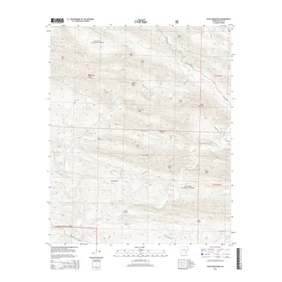
2014 Map of Eagle Mountain
USGS Topo · Published 2014About this map
Ouachita National Forest blankets this corner of Polk County, where the steep ridgelines of the Hanna Range and Eagle Mountain dictate the flow of the upper Cossatot River. This 2014 survey documents the complex network of forest roads and creek-bed hollows that define the local geography. Small settlements and points of interest like Gillham Springs and Dog Hollow are situated along the lower elevations, while the higher terrain is punctuated by landmarks such as Bald Knob, Bear Tusk Mtn, and Smoke Rock Mtn. The river and its numerous tributaries, including Little Brushy Cr and Board Camp Cr, carve deep through the forest, creating the distinctive topography of Dog Mtn and Fodderstack Mtn. The map preserves the specific placement of rural access points like State HWY 375 and Polk Road 80 as they navigate the ridges of the Ouachita Mountains.
Find a feature on this map
51 named features on this map. Tap any name to fly to it.
Don’t see what you’re looking for? This feature index may not catch every label — zoom into the map to look around manually.
Map Details
Editions of this 2014 Eagle Mountain Map
This is the sole edition of this map. No revisions or reprints were ever made.
Other maps of this area

1890 · Poteau Mountain
USGS Topo · 1:125,000

1899 · Poteau Mountain
USGS Topo · 1:125,000

1913 · De Queen
USGS Topo · 1:125,000

1950 · Mcalester
USGS Topo · 1:250,000
1958 · Board Camp
USGS Topo · 1:24,000

1958 · Mena
USGS Topo · 1:62,500

1958 · Potter
USGS Topo · 1:62,500

1958 · Mena
USGS Topo · 1:24,000
1958 · Potter
USGS Topo · 1:24,000

1959 · Umpire
USGS Topo · 1:62,500