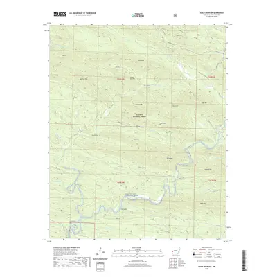
2020 Map of Eagle Mountain
USGS Topo · Published 2020About this map
The Cossatot Wild and Scenic River defines the southern portion of this landscape, winding through a dense network of ridges within the Ouachita National Forest. This 2020 survey highlights a terrain dominated by distinct summits and high gaps, such as Eagle Mountain and the Hanna Range. The presence of several Wolf Pen Gap trails and forest service roads like State Hwy 375 suggests a region heavily utilized for outdoor recreation and backcountry access. Local hydrology is intricate, with numerous drainage systems including Brushy Creek, Caney Creek, and Holly Creek feeding into the primary river corridor. While mostly uninhabited forest land, the map identifies small landmarks like Gillham Springs and family-named features such as West Hanna Mountain and Porter Mountain, providing useful reference points for local history research.
Find a feature on this map
86 named features on this map. Tap any name to fly to it.
Don’t see what you’re looking for? This feature index may not catch every label — zoom into the map to look around manually.
Map Details
Editions of this 2020 Eagle Mountain Map
This is the sole edition of this map. No revisions or reprints were ever made.
Other maps of this area

1890 · Poteau Mountain
USGS Topo · 1:125,000

1899 · Poteau Mountain
USGS Topo · 1:125,000

1913 · De Queen
USGS Topo · 1:125,000

1950 · Mcalester
USGS Topo · 1:250,000
1958 · Board Camp
USGS Topo · 1:24,000

1958 · Mena
USGS Topo · 1:62,500

1958 · Potter
USGS Topo · 1:62,500

1958 · Mena
USGS Topo · 1:24,000
1958 · Potter
USGS Topo · 1:24,000

1959 · Umpire
USGS Topo · 1:62,500