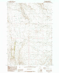
1985 Map of Eagle Pass
USGS Topo · Published 1985About this map
Eagle Pass serves as a primary geographic marker in this 1985 survey of Park County, Wyoming. The terrain is defined by its drainage patterns and named geological formations, notably the systems of Oregon Coulee and Coal Mine Gulch. These features suggest a landscape shaped by historical resource extraction and the seasonal movement of water through the High Plains. The network of waterways, including North Fork Dry Creek and Dry Creek, alongside the presence of Mud Lake, illustrates the drainage profile of the region's semi-arid environment during the mid-1980s. This USGS provisional map captures the precise topographic contours of the area's plateaus and depressions as they existed before modern developments potentially altered the surface drainage and access routes.
Find a feature on this map
6 named features on this map. Tap any name to fly to it.
Don’t see what you’re looking for? This feature index may not catch every label — zoom into the map to look around manually.
Map Details
Editions of this 1985 Eagle Pass Map
This is the sole edition of this map. No revisions or reprints were ever made.
Other maps of this area

1911 · Oregon Basin
USGS Topo · 1:62,500

1913 · Oregon Basin
USGS Topo · 1:62,500

1951 · Y U Bench NW
USGS Topo · 1:24,000

1951 · Sheets Flat
USGS Topo · 1:24,000

1955 · Cody
USGS Topo · 1:250,000

1958 · Cody
USGS Topo · 1:250,000

1962 · Cody
USGS Topo · 1:250,000

1966 · Stone Barn Camp
USGS Topo · 1:24,000

1966 · Corbett Dam
USGS Topo · 1:24,000

1966 · Gilmore Hill
USGS Topo · 1:24,000