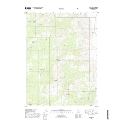
2018 Map of Eagle Peak
USGS Topo · Published 2018About this map
Eagle Peak and Dusenbury Peak dominate the skyline of the Warner Mountains within the Modoc National Forest in this 2018 survey. The landscape is defined by its dramatic verticality and complex drainage systems, where alpine waters feed into North Emerson Lake and South Emerson Lake. A network of high-elevation routes, including the Summit Trail and Owl Creek Trail, provides access to these peaks and the surrounding basins. Evidence of historic land management and recreational development is visible through features like the Bowman Ditch and the Emerson Canyon CG near the Modoc Natural Bridge. The eastern portion of the sheet drops toward the edge of Surprise Valley, showing the transition from mountain crests to the valley floor. Poison Flat in the southwest corner marks a distinct plateau, served by the Poison Flat Trail and several seasonal creek branches.
Find a feature on this map
47 named features on this map. Tap any name to fly to it.
Don’t see what you’re looking for? This feature index may not catch every label — zoom into the map to look around manually.
Map Details
Editions of this 2018 Eagle Peak Map
This is the sole edition of this map. No revisions or reprints were ever made.
Other maps of this area

1886 · Alturas
USGS Topo · 1:250,000

1892 · Alturas
USGS Topo · 1:250,000

1954 · Alturas
USGS Topo · 1:250,000

1958 · Alturas
USGS Topo · 1:250,000

1962 · Alturas
USGS Topo · 1:250,000

1962 · Snake Lake
USGS Topo · 1:24,000

1962 · Jess Valley
USGS Topo · 1:24,000
1962 · Emerson Peak
USGS Topo · 1:24,000

1963 · Warren Peak
USGS Topo · 1:24,000
1963 · Hansen Island
USGS Topo · 1:24,000