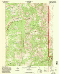
1993 Map of Eagle Peak
USGS Topo · Published 1996About this map
The Warner Mountains dominate this 1993 field-checked survey, providing a detailed look at the high-elevation terrain of the Modoc National Forest. The landscape is defined by its drainage systems, where South Pine Creek and Owl Creek carve through the northern reaches, while the South Warner Wilderness protects the higher summits of Eagle Peak and Cole Peak. The transition from the high peaks down toward the Surprise Valley floor is marked by steep eastern slopes and numerous seasonal Springs.
Find a feature on this map
35 named features on this map. Tap any name to fly to it.
Don’t see what you’re looking for? This feature index may not catch every label — zoom into the map to look around manually.
Map Details
Editions of this 1993 Eagle Peak Map
This is the sole edition of this map. No revisions or reprints were ever made.
Other maps of this area

1886 · Alturas
USGS Topo · 1:250,000

1892 · Alturas
USGS Topo · 1:250,000

1954 · Alturas
USGS Topo · 1:250,000

1958 · Alturas
USGS Topo · 1:250,000

1962 · Alturas
USGS Topo · 1:250,000

1962 · Snake Lake
USGS Topo · 1:24,000

1962 · Jess Valley
USGS Topo · 1:24,000
1962 · Emerson Peak
USGS Topo · 1:24,000

1963 · Warren Peak
USGS Topo · 1:24,000
1963 · Hansen Island
USGS Topo · 1:24,000