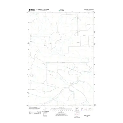
2011 Map of Eagle Point
USGS Topo · Published 2011About this map
Eagle Point and the surrounding high ground of the Montana plains define this region of Stillwater County, where the landscape is marked by a complex network of seasonal drainage and prominent landmarks. The elevation is anchored by Haystack Butte in the west and Antelope Butte further east, providing navigational points above the lower coulees. An intricate system of watercourses, including Shed Gulch Creek, Cabin Gulch Creek, and Painted Robe Creek, illustrates the erosional patterns of the local watershed. Human imprint on this rural area is primarily visible through a grid of secondary roads such as Cushman Rd and Custer Gulch Rd, which connect isolated sections of the plains. The convergence of Gooseneck Creek and Painted Robe Creek in the southeast highlights the natural flow of the terrain toward larger drainage basins beyond the quadrangle's edges.
Find a feature on this map
15 named features on this map. Tap any name to fly to it.
Don’t see what you’re looking for? This feature index may not catch every label — zoom into the map to look around manually.
Map Details
Editions of this 2011 Eagle Point Map
This is the sole edition of this map. No revisions or reprints were ever made.
Other maps of this area

1889 · Big Snowy Mountain
USGS Topo · 1:250,000

1893 · Big Snowy Mountain
USGS Topo · 1:250,000

1954 · Roundup
USGS Topo · 1:250,000

1958 · Roundup
USGS Topo · 1:250,000

1979 · Roundup
USGS Topo · 1:100,000

1979 · Lavina
USGS Topo · 1:24,000

1979 · Belmont
USGS Topo · 1:24,000
1980 · Broadview West
USGS Topo · 1:24,000
1985 · Hailstone Basin
USGS Topo · 1:24,000
1985 · Hailstone Basin SE
USGS Topo · 1:24,000