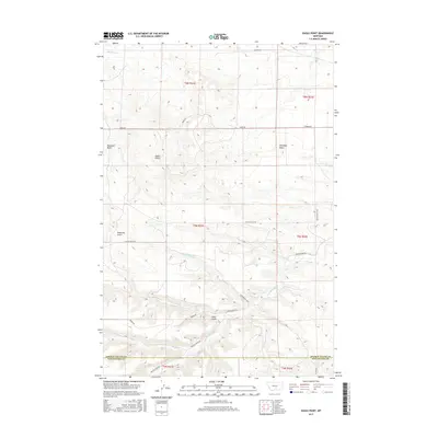
2017 Map of Eagle Point
USGS Topo · Published 2017About this map
Eagle Point and the surrounding high country of the Big Snowy Mountains foothills dominate this landscape along the border of Stillwater and Golden Valley counties. The terrain is defined by a series of prominent rises including Haystack Butte to the west and Antelope Butte to the east, overlooking a network of drainages that carve through the upland. Waterways such as Big Coulee Cr and Painted Robe Cr follow the natural contours of the land, while smaller tributaries like Shed Gulch Cr and Hop Cr drain the central gulches. A network of rural routes, including Custer Gulch Rd and Painted Robe Rd, provides access across the township lines of the Public Land Survey System. This area remains primarily characterized by its geographic landmarks and open ranching country, with the survey capturing the intersections of Stockade Gulch and Cabin Gulch as they descend toward the lower plains.
Find a feature on this map
25 named features on this map. Tap any name to fly to it.
Don’t see what you’re looking for? This feature index may not catch every label — zoom into the map to look around manually.
Map Details
Editions of this 2017 Eagle Point Map
This is the sole edition of this map. No revisions or reprints were ever made.
Other maps of this area

1889 · Big Snowy Mountain
USGS Topo · 1:250,000

1893 · Big Snowy Mountain
USGS Topo · 1:250,000

1954 · Roundup
USGS Topo · 1:250,000

1958 · Roundup
USGS Topo · 1:250,000

1979 · Roundup
USGS Topo · 1:100,000

1979 · Lavina
USGS Topo · 1:24,000

1979 · Belmont
USGS Topo · 1:24,000
1980 · Broadview West
USGS Topo · 1:24,000
1985 · Hailstone Basin
USGS Topo · 1:24,000
1985 · Hailstone Basin SE
USGS Topo · 1:24,000