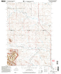
2005 Map of Eagles Nest Butte
USGS Topo · Published 2007About this map
The North Dakota South Dakota border splits this high plains landscape, where the Grand River and its North Fork wind through a territory defined by remote ranching and public lands. In the southern portion of the sheet, the northern reaches of Slim Buttes rise sharply within the Custer National Forest, creating a distinct vertical break from the surrounding grassland. Landmarks like Eagles Nest Butte and Fuller Pass provide navigational anchors in an area where human presence is sparse but deeply rooted.
Find a feature on this map
21 named features on this map. Tap any name to fly to it.
Don’t see what you’re looking for? This feature index may not catch every label — zoom into the map to look around manually.
Map Details
Editions of this 2005 Eagles Nest Butte Map
This is the sole edition of this map. No revisions or reprints were ever made.
Other maps of this area

1935 · Reva
USGS Topo · 1:125,000

1935 · Buffalo
USGS Topo · 1:125,000

1953 · Dickinson
USGS Topo · 1:250,000

1954 · Lemmon
USGS Topo · 1:250,000

1957 · Dickinson
USGS Topo · 1:250,000

1957 · Lemmon
USGS Topo · 1:250,000

1968 · Bowman SW
USGS Topo · 1:24,000

1968 · Eagles Nest Butte
USGS Topo · 1:24,000

1968 · Ludlow
USGS Topo · 1:24,000

1968 · Tepee Buttes
USGS Topo · 1:24,000