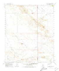
1962 Map of Eagletail Mts
USGS Topo · Published 1981About this map
Eagletail Mountains dominate this high-desert corridor of Western Arizona, bisected by the county line between Yuma and Maricopa. The map highlights a landscape shaped by mining and cattle-grazing interests during the mid-century era, featuring the Double Eagle Mine tucked into the slopes near Double Eagle Peak and the Yellow Breast Mine further south. Notable geological landmarks like the towering Courthouse Rock and a Natural Arch provide essential orientation in a terrain otherwise defined by dry washes like Centennial Wash and Nottbusch Wash. The network of Jeep Trails and the Deadman Trail suggest the era's reliance on rugged access for ranching and mineral exploration across Cemetery Ridge and the Harquahala Plain. Local landmarks such as Clanton Well and various unnamed water tanks illustrate the critical importance of water management in this arid environment.
Find a feature on this map
29 named features on this map. Tap any name to fly to it.
Don’t see what you’re looking for? This feature index may not catch every label — zoom into the map to look around manually.
Map Details
Editions of this 1962 Eagletail Mts Map
3 editions found

Other maps of this area

1927 · Hyder
USGS Topo · 1:62,500

1930 · Hyder
USGS Topo · 1:62,500

1942 · Vicksburg
USGS Topo · 1:250,000

1951 · Dendora Valley
USGS Topo · 1:62,500

1954 · Phoenix
USGS Topo · 1:250,000

1957 · Phoenix
USGS Topo · 1:250,000

1958 · Phoenix
USGS Topo · 1:250,000

1960 · Phoenix
USGS Topo · 1:250,000

1961 · Hope
USGS Topo · 1:62,500

1961 · Lone Mountain
USGS Topo · 1:62,500