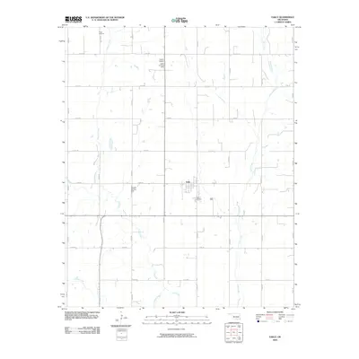
2009 Map of Eakly
USGS Topo · Published 2009About this map
The town of Eakly serves as the central hub of this agricultural landscape in Caddo County, Oklahoma. The map reveals a strictly organized section-line road grid that defines the local transport patterns, punctuated by small private aviation sites including the Lasley Landing Strip and Wheeler Landing Strip. These local strips, along with Lasley Airport, suggest a reliance on aerial services for farming or private travel in this part of the Great Plains.
Find a feature on this map
27 named features on this map. Tap any name to fly to it.
Don’t see what you’re looking for? This feature index may not catch every label — zoom into the map to look around manually.
Map Details
Editions of this 2009 Eakly Map
This is the sole edition of this map. No revisions or reprints were ever made.
Other maps of this area

1951 · Binger
USGS Topo · 1:62,500

1951 · Fort Cobb
USGS Topo · 1:62,500

1955 · Clinton
USGS Topo · 1:250,000

1957 · Clinton
USGS Topo · 1:250,000

1961 · Eakly
USGS Topo · 1:62,500

1961 · Carnegie
USGS Topo · 1:62,500

1979 · Sickles
USGS Topo · 1:24,000
1979 · Fort Cobb Dam
USGS Topo · 1:24,000
1979 · Rock Mary
USGS Topo · 1:24,000

1984 · Eakly
USGS Topo · 1:24,000