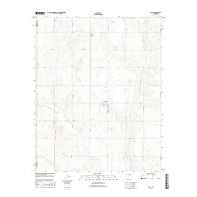
2016 Map of Eakly
USGS Topo · Published 2016About this map
Eakly sits at the heart of this agricultural landscape in Caddo County, organized by a rigid grid of rural routes like Co Rd 1140 and N2490 Rd. This modern survey reveals the persistent structure of a community defined by its watercourses and family legacies. The northern reaches are shaped by the winding path of Fivemile Cr, while Cobb Cr and Crooked Cr carve through the southern terrain, influencing the placement of homesteads and fields. Local history and genealogy are anchored by the Poage Cem in the northwest and Eakly Cem just south of the town center. The presence of the Lasley Private Airport north of town highlights the importance of private aviation in managing these expansive Oklahoma farmsteads. Within the settlement of Eakly itself, the residential grid is detailed along Main St, Cox Ave, and Clifford Ave, providing a clear view of the town's contemporary footprint.
Find a feature on this map
35 named features on this map. Tap any name to fly to it.
Don’t see what you’re looking for? This feature index may not catch every label — zoom into the map to look around manually.
Map Details
Editions of this 2016 Eakly Map
This is the sole edition of this map. No revisions or reprints were ever made.
Other maps of this area

1951 · Binger
USGS Topo · 1:62,500

1951 · Fort Cobb
USGS Topo · 1:62,500

1955 · Clinton
USGS Topo · 1:250,000

1957 · Clinton
USGS Topo · 1:250,000

1961 · Eakly
USGS Topo · 1:62,500

1961 · Carnegie
USGS Topo · 1:62,500

1979 · Sickles
USGS Topo · 1:24,000
1979 · Fort Cobb Dam
USGS Topo · 1:24,000
1979 · Rock Mary
USGS Topo · 1:24,000

1984 · Eakly
USGS Topo · 1:24,000