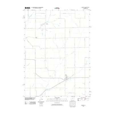
2010 Map of Earling
USGS Topo · Published 2010About this map
Earling serves as the primary hub of this western Iowa landscape, situated where the Earling Post Office and Saint Joseph Cemetery mark the community's heart. The surrounding countryside is defined by a dense grid of rural routes including Elmwood Rd and Street F16, which connect scattered homesteads and agricultural tracts. Waterways such as Mosquito Creek, Moser Creek, and Picayune Creek carve through the section lines, shaping the local topography and influencing the placement of smaller locales like Poma. For those researching family history in Shelby County, the presence of the Latter Day Saints Cemetery to the northwest and the recreational grounds at Camp Manteno provides significant local context. The map illustrates a contemporary rural economy where modern road infrastructure overlays a long-established pattern of midwestern settlement and drainage networks.
Find a feature on this map
37 named features on this map. Tap any name to fly to it.
Don’t see what you’re looking for? This feature index may not catch every label — zoom into the map to look around manually.
Map Details
Editions of this 2010 Earling Map
This is the sole edition of this map. No revisions or reprints were ever made.
Other maps of this area

1954 · Omaha
USGS Topo · 1:250,000

1957 · Omaha
USGS Topo · 1:250,000

1958 · Omaha
USGS Topo · 1:250,000

1971 · Earling
USGS Topo · 1:24,000

1971 · Dunlap
USGS Topo · 1:24,000

1971 · Earling NE
USGS Topo · 1:24,000
1971 · Dow City
USGS Topo · 1:24,000

1971 · Defiance
USGS Topo · 1:24,000
1971 · Dunlap NE
USGS Topo · 1:24,000

1978 · Panama
USGS Topo · 1:24,000