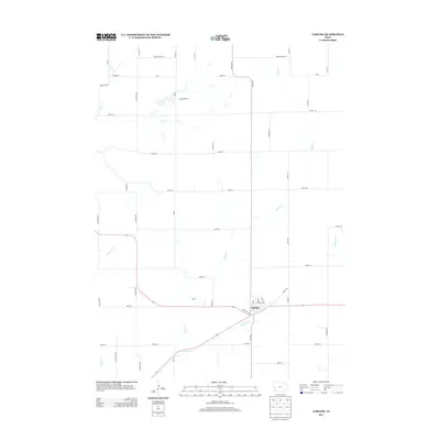
2013 Map of Earling
USGS Topo · Published 2013About this map
Earling serves as the primary hub of activity in this portion of Shelby County, situated where Road M16 meets the local street grid. The surrounding agricultural landscape is defined by a dense network of numbered section-line roads, such as 1900th St and 2200th St, which reflect the region's orderly land survey system. Smaller settlements like Camp Manteno and Poma are interspersed between the winding paths of local waterways. These drainage systems, including Mosquito Cr and Moser Cr, cut through the high ground to create the distinctive drainage patterns characteristic of western Iowa. Researchers can trace the development of local infrastructure through named thoroughfares like Earling Rd and Dogwood Rd, which connect the town center to the outlying farmsteads and rural landmarks across the quadrangle.
Find a feature on this map
42 named features on this map. Tap any name to fly to it.
Don’t see what you’re looking for? This feature index may not catch every label — zoom into the map to look around manually.
Map Details
Editions of this 2013 Earling Map
This is the sole edition of this map. No revisions or reprints were ever made.
Other maps of this area

1954 · Omaha
USGS Topo · 1:250,000

1957 · Omaha
USGS Topo · 1:250,000

1958 · Omaha
USGS Topo · 1:250,000

1971 · Earling
USGS Topo · 1:24,000

1971 · Dunlap
USGS Topo · 1:24,000

1971 · Earling NE
USGS Topo · 1:24,000
1971 · Dow City
USGS Topo · 1:24,000

1971 · Defiance
USGS Topo · 1:24,000
1971 · Dunlap NE
USGS Topo · 1:24,000

1978 · Panama
USGS Topo · 1:24,000