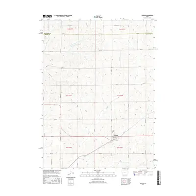
2015 Map of Earling
USGS Topo · Published 2015About this map
Earling serves as the primary hub in this corner of Shelby County, where a grid of rural section roads divides a landscape defined by an intricate network of waterways. The town center is structured around Railway St, 2nd St, and 3rd St, reflecting the historical influence of rail lines on local settlement patterns. Significant local heritage is preserved at Saint Joseph Cem just north of town and the Latter Day Saints Cem further northwest, both of which serve as vital markers for genealogical research in the region.
Find a feature on this map
31 named features on this map. Tap any name to fly to it.
Don’t see what you’re looking for? This feature index may not catch every label — zoom into the map to look around manually.
Map Details
Editions of this 2015 Earling Map
This is the sole edition of this map. No revisions or reprints were ever made.
Other maps of this area

1954 · Omaha
USGS Topo · 1:250,000

1957 · Omaha
USGS Topo · 1:250,000

1958 · Omaha
USGS Topo · 1:250,000

1971 · Earling
USGS Topo · 1:24,000

1971 · Dunlap
USGS Topo · 1:24,000

1971 · Earling NE
USGS Topo · 1:24,000
1971 · Dow City
USGS Topo · 1:24,000

1971 · Defiance
USGS Topo · 1:24,000
1971 · Dunlap NE
USGS Topo · 1:24,000

1978 · Panama
USGS Topo · 1:24,000