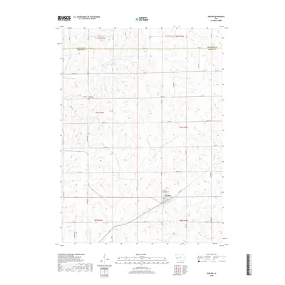
2018 Map of Earling
USGS Topo · Published 2018About this map
Earling serves as the primary hub of this Shelby County landscape, situated where the terrain drops toward the banks of Mosquito Cr. The settlement pattern is defined by a dense grid of section lines and gravel roads, including Washington Ave and Railway St, which navigate the high ridges between numerous branching waterways. Significant for local genealogy, the area contains the Saint Joseph Cem near the town center and the Latter Day Saints Cem located further north. The landscape is deeply dissected by a drainage network comprising Mill Cr, Moser Cr, Picayune Cr, and Pigeon Cr, illustrating the typical loess hills topography of western Iowa. These stream corridors dictate the placement of rural farmsteads and the winding secondary routes that connect them across the township boundaries.
Find a feature on this map
31 named features on this map. Tap any name to fly to it.
Don’t see what you’re looking for? This feature index may not catch every label — zoom into the map to look around manually.
Map Details
Editions of this 2018 Earling Map
This is the sole edition of this map. No revisions or reprints were ever made.
Other maps of this area

1954 · Omaha
USGS Topo · 1:250,000

1957 · Omaha
USGS Topo · 1:250,000

1958 · Omaha
USGS Topo · 1:250,000

1971 · Earling
USGS Topo · 1:24,000

1971 · Dunlap
USGS Topo · 1:24,000

1971 · Earling NE
USGS Topo · 1:24,000
1971 · Dow City
USGS Topo · 1:24,000

1971 · Defiance
USGS Topo · 1:24,000
1971 · Dunlap NE
USGS Topo · 1:24,000

1978 · Panama
USGS Topo · 1:24,000