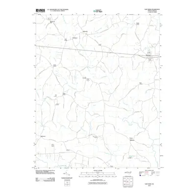
2010 Map of East Bend
USGS Topo · Published 2010About this map
East Bend and the surrounding rural communities of Yadkin County are defined by a network of small family and church-affiliated settlements such as Forbush, Poindexter, and Sugartown. The landscape is etched by numerous tributaries including Forbush Creek, Logan Creek, and Hall Creek, which drain the agricultural terrain. Of significant interest to genealogists is the concentration of historic burial grounds, such as the Richmond Hill Cemetery in the north and the East Bend Friends Cemetery, reflecting the region's deep Quaker and pioneer roots.
Find a feature on this map
86 named features on this map. Tap any name to fly to it.
Don’t see what you’re looking for? This feature index may not catch every label — zoom into the map to look around manually.
Map Details
Editions of this 2010 East Bend Map
This is the sole edition of this map. No revisions or reprints were ever made.
Other maps of this area

1891 · Yadkinville
USGS Topo · 1:125,000

1893 · Yadkinville
USGS Topo · 1:125,000

1953 · Winston-Salem
USGS Topo · 1:250,000

1955 · Winston-Salem
USGS Topo · 1:250,000

1962 · Winston-Salem
USGS Topo · 1:250,000

1964 · Pinnacle
USGS Topo · 1:24,000
1966 · Farmington
USGS Topo · 1:24,000
1966 · Lone Hickory
USGS Topo · 1:24,000

1966 · Yadkinville
USGS Topo · 1:24,000

1966 · East Bend
USGS Topo · 1:24,000