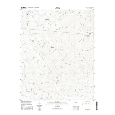
2016 Map of East Bend
USGS Topo · Published 2016About this map
Richmond Hill and the surrounding rural communities of Smithtown and Union Grove define this portion of Yadkin County. The landscape is characterized by a dense network of local roads and creek drainages, including Fall Cr and Little Forbush Cr. For genealogists, the map is remarkably thorough in its documentation of local burial sites, from the Richmond Hill Cem in the northwest to the East Bend Friends Cem near the town of East Bend. The distribution of these sites, alongside namesake landmarks like Patterson Grove Cem and Mount Carmel Cem, reflects a deeply rooted settlement pattern. Small water bodies like Brown Lake and Phillips Pond punctuate the terrain, while the course of Forbush Cr winds through the central valley toward the community of Forbush.
Find a feature on this map
137 named features on this map. Tap any name to fly to it.
Don’t see what you’re looking for? This feature index may not catch every label — zoom into the map to look around manually.
Map Details
Editions of this 2016 East Bend Map
This is the sole edition of this map. No revisions or reprints were ever made.
Other maps of this area

1891 · Yadkinville
USGS Topo · 1:125,000

1893 · Yadkinville
USGS Topo · 1:125,000

1953 · Winston-Salem
USGS Topo · 1:250,000

1955 · Winston-Salem
USGS Topo · 1:250,000

1962 · Winston-Salem
USGS Topo · 1:250,000

1964 · Pinnacle
USGS Topo · 1:24,000
1966 · Farmington
USGS Topo · 1:24,000
1966 · Lone Hickory
USGS Topo · 1:24,000

1966 · Yadkinville
USGS Topo · 1:24,000

1966 · East Bend
USGS Topo · 1:24,000