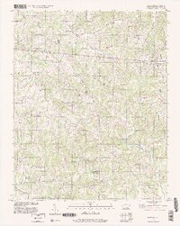
1996 Map of East Bend
USGS Topo · Published 2000About this map
East Bend and the surrounding rural communities of Yadkin County are captured here at the close of the 20th century. The landscape is defined by the dendritic drainage patterns of Forbush Creek and Deep Creek, which cut through the terrain to create a mosaic of ridges and hollows. Local centers such as Smithtown and Union Grove serve as anchors for a network of country roads including Siloam Road and Richmond Hill Road.
Find a feature on this map
47 named features on this map. Tap any name to fly to it.
Don’t see what you’re looking for? This feature index may not catch every label — zoom into the map to look around manually.
Map Details
Editions of this 1996 East Bend Map
This is the sole edition of this map. No revisions or reprints were ever made.
Other maps of this area

1891 · Yadkinville
USGS Topo · 1:125,000

1893 · Yadkinville
USGS Topo · 1:125,000

1953 · Winston-Salem
USGS Topo · 1:250,000

1955 · Winston-Salem
USGS Topo · 1:250,000

1962 · Winston-Salem
USGS Topo · 1:250,000

1964 · Pinnacle
USGS Topo · 1:24,000
1966 · Farmington
USGS Topo · 1:24,000
1966 · Lone Hickory
USGS Topo · 1:24,000

1966 · Yadkinville
USGS Topo · 1:24,000

1966 · East Bend
USGS Topo · 1:24,000