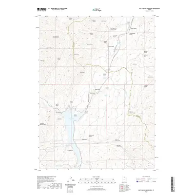
2020 Map of East Canyon Reservoir
USGS Topo · Published 2020About this map
East Canyon Reservoir dominates the drainage system of this portion of the Wasatch Range, where the boundary between Morgan and Summit counties follows the high ridgelines. The landscape is a complex network of canyons and hollows, including Main Canyon and Bishops Canyon, that converge toward the reservoir's waters. Of significant historical interest is the Rte of Donner Reed Party, which traverses the high ground near Hogback Summit. This corridor, along with the Broad Hollow Pioneer Trl, highlights the area's role as a formidable passage for early westward migration. Numerous localized water sources such as Jack Beard Spring and Tom Porter Springs appear throughout the varied terrain, which rises to prominent points like Redrock Peak and the geological formation of Rocky Ridge.
Find a feature on this map
59 named features on this map. Tap any name to fly to it.
Don’t see what you’re looking for? This feature index may not catch every label — zoom into the map to look around manually.
Map Details
Editions of this 2020 East Canyon Reservoir Map
This is the sole edition of this map. No revisions or reprints were ever made.
Other maps of this area

1885 · Salt Lake
USGS Topo · 1:250,000

1900 · Coalville
USGS Topo · 1:125,000

1903 · Coalville
USGS Topo · 1:125,000

1925 · Ft. Douglas
USGS Topo · 1:125,000

1928 · Ft. Douglas
USGS Topo · 1:125,000

1954 · Salt Lake City
USGS Topo · 1:250,000

1954 · Ogden
USGS Topo · 1:250,000

1958 · Ogden
USGS Topo · 1:250,000

1958 · Salt Lake City
USGS Topo · 1:250,000

1960 · Ogden
USGS Topo · 1:250,000