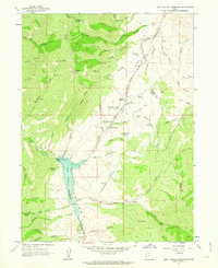
1961 Map of East Canyon Reservoir
USGS Topo · Published 1963About this map
Mormon Pioneers and Donner-Reed Party Route winds across this landscape, tracing the high ridges and hollows north of the East Canyon Reservoir. This survey captures the intersection of early Western migration history and mid-century water management. Along the historic trail, specific landmarks like the Site of Dixie Hollow Pony Express Sta and the Dixie Hollow Springs (Historic Campsite) mark critical stopping points for travelers. The terrain is defined by a dense network of named drainages including Bishops Canyon, Pollicks Canyon, and Thomas Hollow, all feeding toward the central reservoir and East Canyon Creek. Local history is anchored by specific family-named sites such as Grants Grave and Tom Porter Springs, while geological features like Redrock Peak and Avalanche Cave dominate the western heights.
Find a feature on this map
93 named features on this map. Tap any name to fly to it.
Don’t see what you’re looking for? This feature index may not catch every label — zoom into the map to look around manually.
Map Details
Editions of this 1961 East Canyon Reservoir Map
2 editions found
Other maps of this area

1885 · Salt Lake
USGS Topo · 1:250,000

1900 · Coalville
USGS Topo · 1:125,000

1903 · Coalville
USGS Topo · 1:125,000

1925 · Ft. Douglas
USGS Topo · 1:125,000

1928 · Ft. Douglas
USGS Topo · 1:125,000

1954 · Salt Lake City
USGS Topo · 1:250,000

1954 · Ogden
USGS Topo · 1:250,000

1958 · Ogden
USGS Topo · 1:250,000

1958 · Salt Lake City
USGS Topo · 1:250,000

1960 · Ogden
USGS Topo · 1:250,000