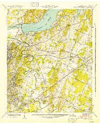
1942 Map of East Chattanooga
USGS Topo · Published 1942About this map
The Chickamauga Dam and its expansive Chickamauga Reservoir dominate this 1941 landscape, a period when the Tennessee Valley Authority was actively reshaping the region's geography and infrastructure. The industrial and transportation identity of the area is evident through the convergence of the Southern Railway and the Nashville Chattanooga and St Louis Railway, which supported growing settlements like East Chattanooga and Tyner.
Find a feature on this map
90 named features on this map. Tap any name to fly to it.
Don’t see what you’re looking for? This feature index may not catch every label — zoom into the map to look around manually.
Map Details
Editions of this 1942 East Chattanooga Map
2 editions found
Other maps of this area

1886 · Ringgold
USGS Topo · 1:125,000

1888 · Chattanooga
USGS Topo · 1:125,000

1892 · Ringgold
USGS Topo · 1:125,000

1893 · Chattanooga
USGS Topo · 1:125,000

1935 · East Chattanooga
USGS Topo · 1:24,000

1935 · Daisy
USGS Topo · 1:24,000

1935 · East Ridge
USGS Topo · 1:24,000

1935 · Ringgold
USGS Topo · 1:24,000

1935 · Snow Hill
USGS Topo · 1:24,000

1935 · Ooltewah
USGS Topo · 1:24,000
Featured Places
- Chattanooga, TN
- East Ridge, TN
- Rollingwood, Chattanooga
- Kings Point, Chattanooga
- Cherokee Woods, Chattanooga