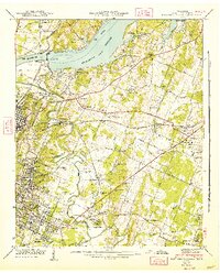
1942 Map of East Chattanooga
USGS Topo · Published 1947About this map
The newly completed Chickamauga Dam and the rising Chickamauga Reservoir dominate this Hamilton County landscape in the early 1940s. The map illustrates a region transitioning from traditional rural communities like Harrison and Tyner toward a suburban and industrial future, shaped by Tennessee Valley Authority projects and the growth of East Chattanooga. The influence of the Southern and Nashville Chattanooga and St Louis railroads is evident as they thread through the terrain beneath Mission Ridge. Local history is deeply embedded in the land, from the Silverdale Confederate Cem to the Bonny Oaks Sch. Near the center of the sheet, the Chattanooga Municipal Airport at Lovell Field represents the era's modern infrastructure, while older landmarks like the County Home and numerous family cemeteries—such as Hancock Cem and Stubblefield Cem—preserve the genealogy of the area.
Find a feature on this map
89 named features on this map. Tap any name to fly to it.
Don’t see what you’re looking for? This feature index may not catch every label — zoom into the map to look around manually.
Map Details
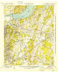
Editions of this 1942 East Chattanooga Map
2 editions found
Other maps of this area

1886 · Ringgold
USGS Topo · 1:125,000

1888 · Chattanooga
USGS Topo · 1:125,000

1892 · Ringgold
USGS Topo · 1:125,000

1893 · Chattanooga
USGS Topo · 1:125,000

1935 · East Chattanooga
USGS Topo · 1:24,000

1935 · Daisy
USGS Topo · 1:24,000

1935 · East Ridge
USGS Topo · 1:24,000

1935 · Ringgold
USGS Topo · 1:24,000

1935 · Snow Hill
USGS Topo · 1:24,000

1935 · Ooltewah
USGS Topo · 1:24,000
Featured Places
- Chattanooga, TN
- East Ridge, TN
- Rollingwood, Chattanooga
- Kings Point, Chattanooga
- Cherokee Woods, Chattanooga