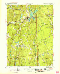
1950 Map of East Killingly
USGS Topo · Published 1950About this map
The Connecticut-Rhode Island border defines this 1943 survey, marking the intersection of the towns of Killingly, Sterling, Glocester, and Foster. The landscape is characterized by a series of north-south running ridges and a complex network of brooks and reservoirs that supported local mills and agriculture. Settlements like East Killingly and Ballouville sit along the winding Fivemile River and Whetstone Brook, while the higher ground is punctuated by landmarks such as Mashentuck Mountain and Jerimoth Hill.
Find a feature on this map
72 named features on this map. Tap any name to fly to it.
Don’t see what you’re looking for? This feature index may not catch every label — zoom into the map to look around manually.
Map Details
Editions of this 1950 East Killingly Map
This is the sole edition of this map. No revisions or reprints were ever made.
Other maps of this area

1889 · Putnam
USGS Topo · 1:62,500

1889 · Burrillville
USGS Topo · 1:62,500

1889 · Moosup
USGS Topo · 1:62,500

1890 · Kent
USGS Topo · 1:62,500

1893 · Putnam
USGS Topo · 1:62,500

1893 · Moosup
USGS Topo · 1:62,500

1894 · Burrillville
USGS Topo · 1:62,500

1894 · Kent
USGS Topo · 1:62,500

1915 · Burrillville
USGS Topo · 1:62,500

1919 · Putnam
USGS Topo · 1:62,500