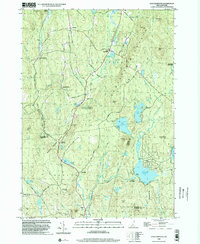
1998 Map of East Lempster
USGS Topo · Published 2002About this map
Ashuelot Pond and the headwaters of the Ashuelot River dominate the landscape of this southern Sullivan County highland during the late 1990s. The terrain is defined by its water and woods, where Honey Brook State Forest and the Dodge Brook State Forest border a network of small millponds and family-named peaks like Kennedy Hill and Bean Mtn. Small settlements and historic crossroads such as Marlow Junction, East Lempster, and Dodge Hollow are connected by winding local routes including Lovejoy Road and Pitkin Road.
Find a feature on this map
75 named features on this map. Tap any name to fly to it.
Don’t see what you’re looking for? This feature index may not catch every label — zoom into the map to look around manually.
Map Details
Editions of this 1998 East Lempster Map
This is the sole edition of this map. No revisions or reprints were ever made.
Other maps of this area

1902 · Sunapee
USGS Topo · 1:62,500

1905 · Sunapee
USGS Topo · 1:62,500

1907 · Sunapee
USGS Topo · 1:62,500

1926 · Claremont
USGS Topo · 1:62,500

1927 · Bellows Falls
USGS Topo · 1:48,000

1929 · Claremont
USGS Topo · 1:62,500

1930 · Lovewell Mountain
USGS Topo · 1:62,500

1930 · Bellows Falls
USGS Topo · 1:62,500

1942 · Lovewell Mountain
USGS Topo · 1:62,500

1950 · Glens Falls
USGS Topo · 1:250,000