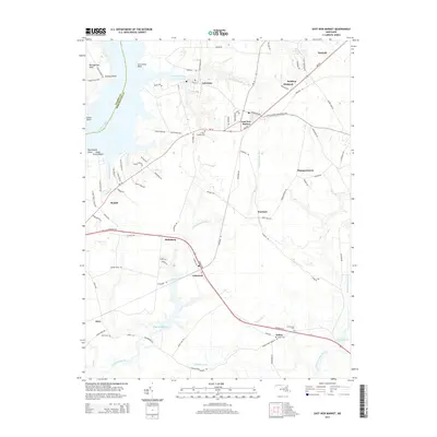
2014 Map of East New Market
USGS Topo · Published 2014About this map
Secretary and East New Market sit at the center of this Dorchester County landscape, where the tidal reaches of the Warwick River and the Choptank River meet a network of inland streams and millponds. The map illustrates a region defined by its water-dependent geography, featuring significant bodies like Higgins Millpond and Big Millpond along the Chicamacomico River and Transquaking River. Settlement patterns follow the high ground between these wetlands, connected by historic routes like Railroad Ave and Ocean Gtwy. For genealogists and local historians, the sheet preserves the locations of several community burial grounds, including Mt Pleasant Cem and Salem Cem, alongside smaller crossroads such as Linkwood and Thompsontown. This coastal plain environment transitions from the shoreline at Cedar Grove Beach and Jamaica Point to the agricultural interior, documenting the persistent rural character of the Eastern Shore in the early 21st century.
Find a feature on this map
96 named features on this map. Tap any name to fly to it.
Don’t see what you’re looking for? This feature index may not catch every label — zoom into the map to look around manually.
Map Details
Editions of this 2014 East New Market Map
This is the sole edition of this map. No revisions or reprints were ever made.
Other maps of this area

1898 · Choptank
USGS Topo · 1:125,000

1898 · St. Marys
USGS Topo · 1:125,000

1903 · Nanticoke
USGS Topo · 1:62,500

1904 · Oxford
USGS Topo · 1:62,500

1905 · Crapo
USGS Topo · 1:62,500

1905 · Hurlock
USGS Topo · 1:62,500

1906 · St. Marys
USGS Topo · 1:125,000

1908 · Choptank
USGS Topo · 1:125,000
1942 · Trappe
USGS Topo · 1:24,000

1942 · Mardela Springs
USGS Topo · 1:24,000