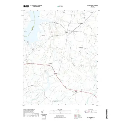
2019 Map of East New Market
USGS Topo · Published 2019About this map
Secretary and East New Market anchor this Dorchester County landscape, where the agricultural interior meets the tidal reaches of the Choptank River and Warwick River. The mapping reveals a network of rural hamlets including Hurlock, Hicksburg, and Linkwood, connected by a web of local roads such as Suicide Bridge RD and Railroad Ave. This region is defined by its low-lying hydrology, with the Transquaking River and Chicamacomico River carving through extensive wetlands and wooded areas like Bolingbroke Neck. Genealogists will find several burial sites preserved in the record, including East New Market Cem, Airey Cem, and Salem Cem near the settlement of Salem. The intersection of historical river-based commerce and modern transit routes is evident in the transition from points like Secretarys Point to the corridors of the Ocean Gateway.
Find a feature on this map
98 named features on this map. Tap any name to fly to it.
Don’t see what you’re looking for? This feature index may not catch every label — zoom into the map to look around manually.
Map Details
Editions of this 2019 East New Market Map
This is the sole edition of this map. No revisions or reprints were ever made.
Other maps of this area

1898 · Choptank
USGS Topo · 1:125,000

1898 · St. Marys
USGS Topo · 1:125,000

1903 · Nanticoke
USGS Topo · 1:62,500

1904 · Oxford
USGS Topo · 1:62,500

1905 · Crapo
USGS Topo · 1:62,500

1905 · Hurlock
USGS Topo · 1:62,500

1906 · St. Marys
USGS Topo · 1:125,000

1908 · Choptank
USGS Topo · 1:125,000
1942 · Trappe
USGS Topo · 1:24,000

1942 · Mardela Springs
USGS Topo · 1:24,000