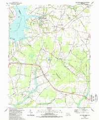
1988 Map of East New Market
USGS Topo · Published 1988About this map
Secretary and East New Market anchor the northern landscape of this Dorchester County survey, where the Warwick River and Goose Cr meet the wide Choptank River. The map details a transition from the tidal points of Jamaica Point and Oystershell Point to the inland agricultural and timbered reaches of the Eastern Shore. Extensive water systems dominate the southern half, including the Chicamacomico River and Higgins Millpond, which reflect the historic importance of water power and drainage in the region's development.
Find a feature on this map
82 named features on this map. Tap any name to fly to it.
Don’t see what you’re looking for? This feature index may not catch every label — zoom into the map to look around manually.
Map Details
Editions of this 1988 East New Market Map
This is the sole edition of this map. No revisions or reprints were ever made.
Other maps of this area

1898 · Choptank
USGS Topo · 1:125,000

1898 · St. Marys
USGS Topo · 1:125,000

1903 · Nanticoke
USGS Topo · 1:62,500

1904 · Oxford
USGS Topo · 1:62,500

1905 · Crapo
USGS Topo · 1:62,500

1905 · Hurlock
USGS Topo · 1:62,500

1906 · St. Marys
USGS Topo · 1:125,000

1908 · Choptank
USGS Topo · 1:125,000
1942 · Trappe
USGS Topo · 1:24,000

1942 · Mardela Springs
USGS Topo · 1:24,000