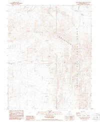
1987 Map of East of Beatty Mtn.
USGS Topo · Published 1987About this map
Yucca Mountain dominates this high-desert landscape in Nye County, Nevada, as it appeared in the late 1980s. This survey focuses on the arid, geologically complex terrain where the Nellis Air Force Range boundary line cuts through the ridges and valleys of the Great Basin. The drainage patterns are defined by ephemeral watercourses such as Beatty Wash, Buttonhook Wash, and Windy Wash, illustrating the harsh hydrological environment. Human presence is marked by various Prospects scattered across the higher elevations, indicating localized mineral exploration efforts. A series of bench marks and survey points, including BM 4154.7 8jd, provide precise topographical data for this high-altitude region. The map captures a moment before significant modern changes, documenting a desert landscape defined by isolation and military reservation boundaries.
Find a feature on this map
26 named features on this map. Tap any name to fly to it.
Don’t see what you’re looking for? This feature index may not catch every label — zoom into the map to look around manually.
Map Details
Editions of this 1987 East of Beatty Mtn. Map
This is the sole edition of this map. No revisions or reprints were ever made.
Other maps of this area

1908 · Kawich
USGS Topo · 1:250,000

1908 · Furnace Creek
USGS Topo · 1:250,000

1910 · Furnace Creek
USGS Topo · 1:250,000

1942 · Tolicha Peak
USGS Topo · 1:125,000

1942 · Wheelbarrow Peak
USGS Topo · 1:125,000

1942 · Skull Mountain
USGS Topo · 1:125,000

1942 · Bullfrog
USGS Topo · 1:125,000

1948 · Death Valley
USGS Topo · 1:250,000

1952 · Topopah Spring
USGS Topo · 1:62,500

1952 · Timber Mountain
USGS Topo · 1:62,500