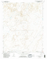
1966 Map of East Of Grey Hill Spring
USGS Topo · Published 1995About this map
The high desert terrain of the Navajo Indian Reservation dominates this 1966 topographic survey, capturing a landscape defined by dramatic elevation changes and remote utility infrastructure. The boundary between San Juan Co and Mc Kinley Co bisects the southern portion of the sheet, cutting through an area where natural drainages and mesa formations dictate the movement of water and travel. While lacking dense settlements, the map reveals the industrial footprint of the mid-1960s through several corridors marked Pipeline, which traverse the desert to connect energy resources across the Four Corners region. These surveyed lines provide a specific record of how modern infrastructure was integrated into the traditional tribal lands during the post-war era.
Find a feature on this map
3 named features on this map. Tap any name to fly to it.
Don’t see what you’re looking for? This feature index may not catch every label — zoom into the map to look around manually.
Map Details
Editions of this 1966 East Of Grey Hill Spring Map
2 editions found
Other maps of this area

1886 · Wingate
USGS Topo · 1:250,000

1889 · Chaco
USGS Topo · 1:250,000

1892 · Wingate
USGS Topo · 1:250,000

1892 · Chaco
USGS Topo · 1:250,000

1954 · Shiprock
USGS Topo · 1:250,000

1954 · Gallup
USGS Topo · 1:250,000

1958 · Gallup
USGS Topo · 1:250,000

1958 · Shiprock
USGS Topo · 1:250,000

1959 · Shiprock
USGS Topo · 1:250,000

1959 · Gallup
USGS Topo · 1:250,000