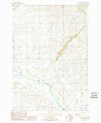
1989 Map of East of Salmon
USGS Topo · Published 1989About this map
The Lemhi River valley serves as the central corridor for this late-twentieth-century landscape, characterized by a complex network of irrigation ditches and flumes that supported agriculture in this high-desert environment. The transition from the fertile river bottom to the arid uplands is marked by industrial activity, most notably the Open Pit Mine and extensive Tailings deposits along Kirtley Creek. These features underscore the region's reliance on mineral extraction alongside ranching. Evidence of community life is found in the local Athletic Field and a designated Graveyard positioned near the valley floor. The convergence of several waterways, including Carmen Creek and Geertson Creek, highlights the importance of water management in the Lemhi area, where the terrain rises sharply from the riverbanks toward the surrounding peaks.
Find a feature on this map
11 named features on this map. Tap any name to fly to it.
Don’t see what you’re looking for? This feature index may not catch every label — zoom into the map to look around manually.
Map Details
Editions of this 1989 East of Salmon Map
This is the sole edition of this map. No revisions or reprints were ever made.
Other maps of this area

1950 · Salmon
USGS Topo · 1:62,500

1951 · Salmon
USGS Topo · 1:62,500

1955 · Dillon
USGS Topo · 1:250,000

1956 · Goldstone Mtn
USGS Topo · 1:62,500

1957 · Dillon
USGS Topo · 1:250,000

1958 · Dillon
USGS Topo · 1:250,000

1962 · Dillon
USGS Topo · 1:250,000

1965 · Dillon
USGS Topo · 1:250,000

1966 · Badger Spring Gulch
USGS Topo · 1:24,000
1966 · Bird Creek
USGS Topo · 1:24,000