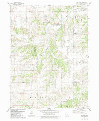
1983 Map of East Peru
USGS Topo · Published 1983About this map
The neighboring settlements of Old Peru and East Peru anchor this part of southern Madison County, illustrating a shift in local center points as the Chicago and North Western railroad moved through the valley. The terrain is deeply dissected by a network of waterways including Clanton Creek, Deer Creek, and the South River at the bottom of the map, which creates a complex landscape of ridges and hollows across Walnut and Ohio townships.
Find a feature on this map
23 named features on this map. Tap any name to fly to it.
Don’t see what you’re looking for? This feature index may not catch every label — zoom into the map to look around manually.
Map Details
Editions of this 1983 East Peru Map
This is the sole edition of this map. No revisions or reprints were ever made.
Other maps of this area

1951 · Osceola
USGS Topo · 1:62,500

1951 · St. Charles
USGS Topo · 1:62,500

1951 · Afton
USGS Topo · 1:62,500

1952 · Winterset
USGS Topo · 1:62,500

1954 · Omaha
USGS Topo · 1:250,000

1954 · Des Moines
USGS Topo · 1:250,000

1956 · Des Moines
USGS Topo · 1:250,000

1957 · Des Moines
USGS Topo · 1:250,000

1957 · Omaha
USGS Topo · 1:250,000

1958 · Omaha
USGS Topo · 1:250,000