
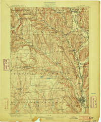
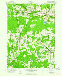
1944 Map of East Pharsalia
USGS Topo · Published 1944About this map
Pharsalia Game Refuge dominates the northern reaches of this mid-century landscape in Chenango County, reflecting a period of state-managed land conservation in New York's Southern Tier. The terrain is defined by elevated ridges like Pigeon Hill and Berry Hill, which separate the various brook and creek systems that drain the upland plateaus. The settlement pattern is largely dispersed, anchored by small hamlets such as North Pharsalia and East Pharsalia, connected by thoroughfares like Old Center Road.
Find a feature on this map
34 named features on this map. Tap any name to fly to it.
Don’t see what you’re looking for? This feature index may not catch every label — zoom into the map to look around manually.
Map Details
Editions of this 1944 East Pharsalia Map
This is the sole edition of this map. No revisions or reprints were ever made.
Other maps of this area

1902 · Coventry
USGS Topo · 1:62,500
1903 · Norwich
USGS Topo · 1:62,500

1904 · Greene
USGS Topo · 1:62,500

1904 · Oxford
USGS Topo · 1:62,500

1904 · Pitcher
USGS Topo · 1:62,500
1943 · Otselic
USGS Topo · 1:24,000
1943 · South Ostelic
USGS Topo · 1:24,000
1943 · Norwich
USGS Topo · 1:24,000
1943 · East Pharsalia
USGS Topo · 1:24,000
1943 · Earlville
USGS Topo · 1:24,000