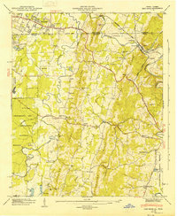
1946 Map of East Ridge
USGS Topo · Published 1947About this map
The Tennessee Georgia state line divides this 1940s landscape, where the growing community of East Ridge meets the ridges and valleys of north Georgia. This era shows the convergence of major travel routes like the Dixie Highway and Ringgold Road alongside the St Louis and San Francisco RR. The map captures a mix of recreation and history, featuring the Lake Winnepesaukah amusement area and the northern fringes of the Chickamauga and Chattanooga National Military Park. Rural life remains anchored by numerous family cemeteries and local institutions such as Lomenick Cem and Graysville Sch. Industry and agriculture are tied to the waterways of West Chickamauga Creek and South Chickamauga Creek, with Swanson Mill still a prominent landmark on the map. The terrain is defined by the parallel elevations of Boynton Ridge and Peavine Ridge, which dictate the placement of older settlements like Boynton and Daffron.
Find a feature on this map
53 named features on this map. Tap any name to fly to it.
Don’t see what you’re looking for? This feature index may not catch every label — zoom into the map to look around manually.
Map Details
Editions of this 1946 East Ridge Map
2 editions found
Other maps of this area

1886 · Ringgold
USGS Topo · 1:125,000

1888 · Chattanooga
USGS Topo · 1:125,000

1892 · Ringgold
USGS Topo · 1:125,000

1893 · Chattanooga
USGS Topo · 1:125,000

1935 · East Chattanooga
USGS Topo · 1:24,000

1935 · East Ridge
USGS Topo · 1:24,000

1935 · Ringgold
USGS Topo · 1:24,000

1935 · Nickajack Gap
USGS Topo · 1:24,000

1935 · Ooltewah
USGS Topo · 1:24,000

1935 · Tunnel Hill
USGS Topo · 1:24,000