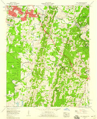
1958 Map of East Ridge
USGS Topo · Published 1959About this map
Chickamauga and Chattanooga National Military Park occupies a significant portion of this landscape, preserving the historical terrain south of East Ridge. This mid-century survey shows the development of the Tennessee-Georgia border, where the Dixie Highway and Ringgold Road intersect with the Louisville and Nashville RR. Modern infrastructure like the Proposed Expressway and an auto speedway appear alongside older features such as Swanson Mill and Anderson Ford. Local history is deeply embedded in the rural areas, marked by numerous small burial grounds like Newman Springs Cem and Dixon Cem. The landscape is defined by the winding course of West Chickamauga Creek as it flows past Boynton and Fort Oglethorpe, creating prominent geographical features like Sycamore Bend.
Find a feature on this map
70 named features on this map. Tap any name to fly to it.
Don’t see what you’re looking for? This feature index may not catch every label — zoom into the map to look around manually.
Map Details
Editions of this 1958 East Ridge Map
2 editions found
Other maps of this area

1886 · Ringgold
USGS Topo · 1:125,000

1888 · Chattanooga
USGS Topo · 1:125,000

1892 · Ringgold
USGS Topo · 1:125,000

1893 · Chattanooga
USGS Topo · 1:125,000

1935 · East Chattanooga
USGS Topo · 1:24,000

1935 · East Ridge
USGS Topo · 1:24,000

1935 · Ringgold
USGS Topo · 1:24,000

1935 · Nickajack Gap
USGS Topo · 1:24,000

1935 · Ooltewah
USGS Topo · 1:24,000

1935 · Tunnel Hill
USGS Topo · 1:24,000