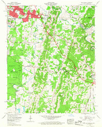
1958 Map of East Ridge
USGS Topo · Published 1967About this map
Chickamauga and Chattanooga National Military Park anchors the southwestern quadrant of this landscape, preserving the terrain of the 1863 battlefield just south of the Tennessee-Georgia state line. The suburban expansion of East Ridge is visible in the north, centered around the Dixie Highway and infrastructure like the McBrien Sch and Town Hall. To the east and south, the terrain becomes more varied as it follows the ridges, with the Louisville and Nashville tracks cutting through Graysville and Ringgold.
Find a feature on this map
66 named features on this map. Tap any name to fly to it.
Don’t see what you’re looking for? This feature index may not catch every label — zoom into the map to look around manually.
Map Details
Editions of this 1958 East Ridge Map
2 editions found
Other maps of this area

1886 · Ringgold
USGS Topo · 1:125,000

1888 · Chattanooga
USGS Topo · 1:125,000

1892 · Ringgold
USGS Topo · 1:125,000

1893 · Chattanooga
USGS Topo · 1:125,000

1935 · East Chattanooga
USGS Topo · 1:24,000

1935 · East Ridge
USGS Topo · 1:24,000

1935 · Ringgold
USGS Topo · 1:24,000

1935 · Nickajack Gap
USGS Topo · 1:24,000

1935 · Ooltewah
USGS Topo · 1:24,000

1935 · Tunnel Hill
USGS Topo · 1:24,000