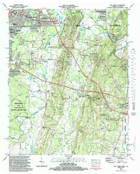
1982 Map of East Ridge
USGS Topo · Published 1983About this map
Chickamauga and Chattanooga National Military Park dominates the western landscape of this Tennessee-Georgia border region, preserving the site of pivotal Civil War movements. This 1982 survey illustrates the suburban expansion around East Ridge and Lakeview, contrasted with the rural, ridge-and-valley terrain to the south and east. The Seaboard System Railroad cuts through the northeast near Graysville, where Swanson Mill stands along the banks of Chickamauga Creek. The map provides a detailed view of local infrastructure, from the Golf Course and Amusement Park near the state line to numerous country churches like Shiloh Ch and Post Oak Ch. Geologists and historians can trace the course of West Chickamauga Creek as it snakes through Sycamore Bend, passing beneath historic crossings such as Reed Bridge and Dyer Bridge.
Find a feature on this map
98 named features on this map. Tap any name to fly to it.
Don’t see what you’re looking for? This feature index may not catch every label — zoom into the map to look around manually.
Map Details
Editions of this 1982 East Ridge Map
2 editions found
Other maps of this area

1886 · Ringgold
USGS Topo · 1:125,000

1888 · Chattanooga
USGS Topo · 1:125,000

1892 · Ringgold
USGS Topo · 1:125,000

1893 · Chattanooga
USGS Topo · 1:125,000

1935 · East Chattanooga
USGS Topo · 1:24,000

1935 · East Ridge
USGS Topo · 1:24,000

1935 · Ringgold
USGS Topo · 1:24,000

1935 · Nickajack Gap
USGS Topo · 1:24,000

1935 · Ooltewah
USGS Topo · 1:24,000

1935 · Tunnel Hill
USGS Topo · 1:24,000