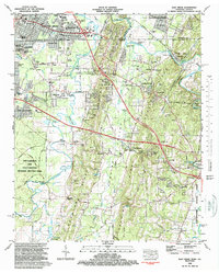
1982 Map of East Ridge
USGS Topo · Published 1988About this map
West Chickamauga Creek winds through the heart of this landscape, a corridor defined by Civil War history and post-war suburban development. The western reaches are dominated by the Chickamauga and Chattanooga National Military Park, while the northern portion shows the expansion of East Ridge and Chattanooga across the Tennessee-Georgia state line. The terrain transitions from the developed flats of Lakeview to the prominent heights of Peavine Ridge and Boynton Ridge. Interchanges along the interstate system signal the era's infrastructure growth, yet the map preserves numerous rural touchstones. Local heritage is deeply rooted in sites like Shiloh Ch, Lomenick Cem, and the settlement at Burning Bush. The Seaboard Coast Line railroad cuts through the northeastern corner near Graysville, linking the river-valley economy to the broader region.
Find a feature on this map
95 named features on this map. Tap any name to fly to it.
Don’t see what you’re looking for? This feature index may not catch every label — zoom into the map to look around manually.
Map Details
Editions of this 1982 East Ridge Map
2 editions found
Other maps of this area

1886 · Ringgold
USGS Topo · 1:125,000

1888 · Chattanooga
USGS Topo · 1:125,000

1892 · Ringgold
USGS Topo · 1:125,000

1893 · Chattanooga
USGS Topo · 1:125,000

1935 · East Chattanooga
USGS Topo · 1:24,000

1935 · East Ridge
USGS Topo · 1:24,000

1935 · Ringgold
USGS Topo · 1:24,000

1935 · Nickajack Gap
USGS Topo · 1:24,000

1935 · Ooltewah
USGS Topo · 1:24,000

1935 · Tunnel Hill
USGS Topo · 1:24,000