
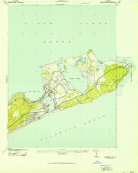
1921 Map of Easthampton
USGS Topo · Published 1921About this map
Amagansett L.S.S. and other Life-Saving Stations stand watch along the shoreline in this Army Corps of Engineers tactical survey, capturing the coastal defenses and maritime character of eastern Long Island in the years following World War I. The Long Island R. R. (Montauk Division) cuts through the landscape, connecting established villages like Easthampton and Amagansett with smaller settlements such as Freetown and Wainscott. This era shows the region before its later density, with large tracts of terrain like Napeague Beach and Georgica Neck remaining relatively open.
Find a feature on this map
28 named features on this map. Tap any name to fly to it.
Don’t see what you’re looking for? This feature index may not catch every label — zoom into the map to look around manually.
Map Details
Editions of this 1921 Easthampton Map
This is the sole edition of this map. No revisions or reprints were ever made.
Other maps of this area

1903 · Sag Harbor
USGS Topo · 1:62,500

1903 · Gardiners Island
USGS Topo · 1:62,500

1904 · Sag Harbor
USGS Topo · 1:62,500

1904 · Shelter Island
USGS Topo · 1:62,500

1904 · Easthampton
USGS Topo · 1:62,500

1904 · Gardiners Island
USGS Topo · 1:62,500

1904 · Montauk
USGS Topo · 1:62,500

1921 · Gardiners Island
USGS Topo · 1:62,500
1942 · Montauk Point
USGS Topo · 1:24,000

1942 · Block Island
USGS Topo · 1:125,000
Featured Places
- Southampton, NY
- East Hampton, NY
- Springs, East Hampton
- East Hampton North, East Hampton
- Northwest Harbor, East Hampton