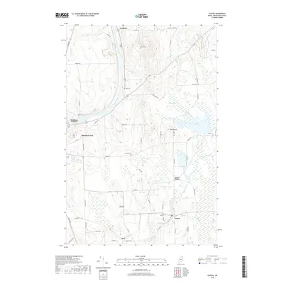
2018 Map of Easton
USGS Topo · Published 2018About this map
The Aroostook River winds through the heart of this Maine landscape, connecting the agricultural hubs of Presque Isle and Easton. This 2018 survey reveals a terrain defined by its farming heritage and small-town junctions, where rail history is still etched into the geography at Washburn Junction and Easton Station. The map is particularly useful for genealogical research, documenting several family-named burial grounds like Bean Cem, Dyer Farm Cem, and Beans Cem. Numerous water bodies including Lake Christina, Bishop Pond, and the flowing Prestile Stream shape the drainage patterns between Melville Hill and the surrounding potato fields. To the south, the settlement of Phair marks an important node in the local transit network, while the layout of Glenwood Park Cem and Estes Park Cem provides a detailed look at the community's established civic spaces.
Find a feature on this map
64 named features on this map. Tap any name to fly to it.
Don’t see what you’re looking for? This feature index may not catch every label — zoom into the map to look around manually.
Map Details
Editions of this 2018 Easton Map
This is the sole edition of this map. No revisions or reprints were ever made.
Other maps of this area

1929 · Caribou
USGS Topo · 1:48,000

1930 · Fort Fairfield
USGS Topo · 1:48,000

1932 · Caribou
USGS Topo · 1:62,500

1933 · Fort Fairfield
USGS Topo · 1:62,500

1935 · Presque Isle
USGS Topo · 1:62,500

1936 · Mars Hill
USGS Topo · 1:48,000

1940 · Mars Hill
USGS Topo · 1:62,500

1951 · Mars Hill
USGS Topo · 1:62,500

1951 · Fort Fairfield
USGS Topo · 1:62,500

1953 · Presque Isle
USGS Topo · 1:62,500