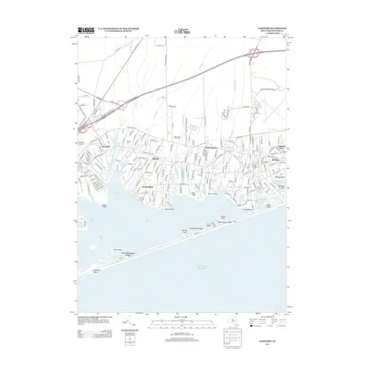
2013 Map of Eastport
USGS Topo · Published 2013About this map
Eastport and Westhampton anchor a coastal landscape defined by the branching inlets of Moriches Bay and Moneyboque Bay on the South Shore of Long Island. This 2013 survey illustrates the dense residential development and maritime infrastructure of the early 21st century, where tidal creeks like Seatuck Cr and Beaverdam Cr serve as natural dividers between the hamlets of Speonk and Remsenburg. The transport corridor is dominated by the Long Island RR and the Sunrise Hwy N Service Rd, while aviation interests are represented by both the Westhampton Beach Airport and the smaller Spadaro Airport. Genealogists and local historians can locate several resting places, including the Eastport Cem, the historic Tuthill Burial Ground, and the unique Bide-A-Wee Animal Cem. Along the barrier beach, the small community of West Hampton Dunes sits between Hart Cove and the open Atlantic Ocean.
Find a feature on this map
178 named features on this map. Tap any name to fly to it.
Don’t see what you’re looking for? This feature index may not catch every label — zoom into the map to look around manually.
Map Details
Editions of this 2013 Eastport Map
This is the sole edition of this map. No revisions or reprints were ever made.
Other maps of this area

1903 · Riverhead
USGS Topo · 1:62,500

1904 · Riverhead
USGS Topo · 1:62,500

1904 · Moriches
USGS Topo · 1:62,500

1943 · Riverhead
USGS Topo · 1:62,500

1947 · Mattituck
USGS Topo · 1:24,000

1947 · Riverhead
USGS Topo · 1:24,000

1947 · Quogue
USGS Topo · 1:24,000

1947 · Eastport
USGS Topo · 1:24,000

1949 · New York
USGS Topo · 1:250,000

1954 · New York
USGS Topo · 1:250,000